How Sceye’s Stratospheric Airships Keep Track Of Greenhouse Gases
1. The Monitoring Gap Is Much Bigger Than Many People Believe.
GHG emissions from global warming are monitored with a mix of ground stations, occasional aerial campaigns, and satellites operating hundreds of kilometers from the earth’s surface. Each of these has its own limitations. Ground stations are scarce and geographically biased towards wealthier nations. Aircraft campaigns are expensive with a short duration and are limited in their coverage. Satellites can be used to cover the globe but struggle to achieve the spatial precision needed to pinpoint particular emission sources, such as the leak of a pipeline, a landfill that releases methane, or an industrial facility not reporting its output. This results in monitoring systems that have serious gaps at precisely the scale where accountability and intervention matters most. Stratospheric platforms are increasingly identified as the missing middle layer.
2. Altitude provides a monitoring advantage Satellites Don’t Have the Ability to Replicate
There’s an argument in geometry for why 20 kilometres beats 500 kilometres when it comes to monitoring emissions. A sensor operating from a stratospheric elevation could be able to observe a footprint of several hundred kilometers while still being close enough identify emission sources with significant resolution. This includes individual facilities roads, road corridors and agricultural zones, and so on. Satellites observing the same area from low Earth orbit can cover it more quickly but with less granularity, and the times to revisit mean that a methane cloud that appears and disappears in a matter of hours could never ever be observed. A station that has its location above a region of interest for a few days or even weeks at a time transforms intermittent snapshots into continuous surveillance.
3. Methane Is the Most Important Target to be able to justify the reason
Carbon dioxide garners the most notice in the media however methane is the greenhouse gas with which immediate improvements to monitoring can make the biggest practical difference. Methane has a higher toxicity than CO2 in a 20-year span and a significant portion of methane emissions from humans originate through point sources — oil and gas infrastructure such as waste facilities, agricultural operations — that are both detectable and in many cases repairable once they’ve been discovered. Real-time monitoring of methane from an ever-present stratospheric platform will mean that operators, regulators, as well as government agencies can see leaks right as they happen rather than discovering them years later when they conduct annual inventory reconciliations that tend to be based on estimates instead of measurements.
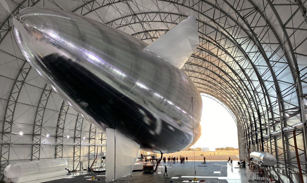
4. Sceye’s Airship Design Is Well for the Monitoring Mission
The traits that make for the best telecommunications platforms and an effective environmental monitoring platform overlap more than you expect. Both require endurance for a long time as well as stable positioning and sufficient payload capacity. Sceye’s lighter-than-air airship approach tackles all three. Because buoyancy performs the essential mission of keeping the aircraft aloft The platform’s energy budget isn’t used up in generating lift that it can be used to power propulsion, station maintenance and powering the particular sensor suit the mission demands. For greenhouse gas monitoring specifically that means carrying imaging systems, spectrometers and data processing tools without having to worry about the extreme weight restrictions that constrain fixed-wing HAPS designs.
5. Station Keeping Is Not Negotiable for Effective Environmental Data
A monitoring platform that has a tendency to drift is a monitoring system that creates information that’s hard to interpret. Knowing exactly where a sensors was at the time of recording a reading is essential for attribution of this reading to the source. Sceye’s emphasis on true stationkeeping — keeping one’s position in relation to a region of focus by active propulsion — isn’t merely a technical performance metric. It’s what makes the results scientifically defensible. Stratospheric earth observation can only be effective for regulatory or legal reasons when the spatial record is reliable enough to stand up to scrutiny. Drifting balloon platforms regardless of how adept their sensors may be, they aren’t able to provide that.
6. The same platform could monitor Oil Pollution and Wildfire Risk During the Same Time
One of the more compelling benefits of the multi-payload design is how seamlessly different environmental monitoring missions can complement one another within the exact same platform. Airships operating in oceans or the coast can include sensors calibrated for detectable oil pollution along with those that monitor CO2 or methane. On land, the same platform architecture allows for wildfire detection technology, allowing for the identification of smoke plumes, heat signatures and indicators of stress in the vegetation that signal ignitions. Sceye’s method of mission design is to treat these as not separate programmes requiring separate aircraft but as use cases in parallel with infrastructure that’s in place and operating.
7. Detecting Climate Disasters with real-time changes the Response Equation
There’s a distinct difference between knowing that a fire started six hours ago and finding out it started 20 minutes in the past. The same is true of industrial accidents releasing harmful gases, flood events inflicting damage to infrastructure, or abrupt methane leaks from permafrost. The ability of detecting climate catastrophes in real time through a constantly operating stratospheric satellite gives emergency personnel the government agencies, emergency managers, and industrial operators an opportunity to intervene that simply doesn’t be present when monitoring relies on earth-based reports. The significance of this window compounds when you consider that the earliest stages of most environmental emergencies an area where intervention is most effective.
8. Its Energy Architecture Makes Long Endurance Monitoring a Viable
Environmental monitoring missions will only bring their maximum value when the platforms remain on station in a sufficient amount of time to make the necessary data record. The methane level for a week over an oil field tells you something. The continuous accumulation of data over months can tell an actionable thing. Being able to maintain that endurance will require solving the problem of energy consumption in the evening -The platform must be able to retain enough power through daylight hours so that it can operate all systems through the night without losing position or sensor function. Technology advancements in lithium-sulfur batteries with energy densities as high as 425 Wh/kg. In addition, an improvement in solar cell efficiency is what makes a truly closed power loop achievable. If neither of these are present, the endurance is only an aspirational rather than an objective.
9. Mikkel Vestergaard’s Past Explains the emphasis on the environment
It’s worth understanding why a stratospheric aerospace company places such apparent emphasis on greenhouse-gas monitoring and disaster prevention rather than focusing solely on connectivity revenue. Mikkel Vestergaard’s experience in using technology to tackle large-scale environmental and humanitarian needs gives Sceye a founding orientation that defines the mission that Sceye prioritizes and how it conveys its platform’s function. The capabilities for monitoring the environment aren’t just a supplementary payload bolted onto the appearance of a telecoms device more socially responsible — they are a true belief that the stratospheric structure should be conducting climate work, and that the same platform will provide both without compromising.
10. The Data Pipeline Is as Important as the Sensor
Rectifying greenhouse gas readings in the stratosphere is only half the problem. getting the data to people who need it, in a form that they can respond to, in similar to real-time is the second part. A stratospheric platform that has onboard processing capability and direct downlink to ground stations is able to reduce the time between detecting and making a decision significantly in comparison to systems that process data for later analysis. for natural resource management or monitoring compliance with regulatory requirements or emergencies, the speed that the data is frequently a concern equally as the accuracy. Integrating the data pipeline into the platform architecture from the start, rather than making it an afterthought is what is differentiating serious stratospheric Earth observation from non-deliberate sensor campaigns. Read the best sceye greenhouse gas monitoring for site info including Sceye Wireless connectivity, Wildfire detection technology, what haps, Monitor Oil Pollution, Stratospheric missions, Diurnal flight explained, japan nation-wide network of softbank corp, marawid, Sceye News, marawid and more.
Fire And Disaster Detection In The Stratosphere
1. The Detection Window is the most useful thing you can extend
Every major catastrophe has a time that can be measured as seconds, sometimes it’s hours — when a quick awareness could have altered the outcome. A wildfire identified when it exceeds half a hectare in size is one of the problems with containing. The fire which was discovered when it covers more than fifty hectares is a catastrophe. An industrial gas leak that is discovered within the first two hours can be isolated before it escalates into a public health emergency. The same issue that is discovered after three hours, either through either a ground report or satellite flying by during its scheduled trip, has changed into a situation that has no solution that is clear. Intending the detection window arguably the single most valuable quality that a modern monitoring infrastructure could provide, and continuous stratospheric imaging is one of the only methods to alter the window with a significant impact, not minimally.
2. It is becoming harder for wildfires to Monitor With Existing Infrastructure
The magnitude and frequency of wildfires in recent years has been greater than the monitoring infrastructure built to track the fires. In-ground detection networks- guard towers, sensor arrays ranger patrols — contain too little territory in a way that they are not able to keep pace with fast-moving fires at their earliest stages. Aircraft response is efficient, but expensive, weather-dependent and is reactive, not anticipatory. Satellites fly over a area in a sequence measured in hours, which results in a fire which blazes it, spreads, or crowns between passes generates no early warning. The combination of more fires that spread faster, accelerated rates of spread caused by drought conditions, and increasingly complex terrain creates a monitoring gap that conventional methods are not able to close structurally.
3. Stratospheric Altitude Provides Persistent Wide-Area Visibility
A platform that is operating at a height of 20 kilometres above surface can provide uninterrupted visibility throughout a land area that is hundreds of kilometers protecting fire-prone areas, coastlines forests, forest margins and urban interfaces simultaneously and without interruption. Contrary to aircrafts and helicopters, this platform doesn’t need to return for fuel. In contrast to satellites it doesn’t disappear into the horizon during the cycle of a revisit. For the purpose of wildfire detection specifically this continuous, wide-area vision means that the device is monitoring whenever the fire is ignited, watching as flames begin to spread, and following the changes in fire behavior in a continuous streaming of data, rather than a succession of snapshots in which emergency managers must cross-check between.
4. Thermal and Multispectral Sensors Are able To Detect Fires before smoke becomes visible.
Some of the most useful fire detection technologies doesn’t wait for visible smoke. Thermal infrared sensors can detect heat anomalies that suggest ignition before an event has generated any visible signature at all by detecting hotspots in dry vegetation, smouldering ground forests, and the early signs of heat that fires are beginning to form. Multispectral imaging provides additional capabilities by detecting changes within the vegetation conditions — such as moisture stress Drying, browningwhich indicate a higher fire risk in specific areas before the ignition event takes place. A stratospheric platform that has this sensor combo gives alerts in advance of active ignition as well as predictive insight about the location the next fire is likely to occur, which is a qualitatively distinct type of situational awareness that traditional monitoring provides.
5. Sceye’s Multi-Payload Strategy Combines Detection With Communications
One of many practical ramifications during major catastrophes is that the infrastructure which people depend on for communication such as mobile towers, power lines, internet connectivity and so on — is often one of those first destroyed or flooded. An stratospheric device that houses both the sensors to detect disasters and a telecommunications payloads will address this problem from one vehicle. Sceye’s design approach to mission planning treats connectivity and observation as functionally related rather than competing types, which means that the same platform that can detect a growing wildfire is also able to provide emergency communications to personnel in the field whose land networks are dark. The cell tower in space does not just view the calamity — it keeps people connected by it.
6. This extends the scope of disaster detection well beyond Wildfires
While wildfires represent one of the most compelling use cases for ongoing stratospheric monitoring this same platform’s capabilities can be utilized to a wider range of scenarios for disaster. Floods can be monitored when they occur across areas of coastal zones and river systems. Aftershocks from earthquakes — that include impaired infrastructure, blocked roads and population displacementget the benefit of a quick wide-area assessment that ground teams are not able to provide quickly enough. Industrial accidents that release hazardous gases or oil polluting into the oceans produce signatures that can be detected by sensors of the stratospheric height. Monitoring climate disasters in real time across all types of categories requires a element that is in constant motion at all times, watching constantly, and able to distinguish from normal variations in environmental conditions and the signs of developing emergencies.
7. Japan’s Disaster Profile Makes the Sceye Partnership Especially Relevant
Japan is a major participant of the world’s significant seismic natural disasters. It also experiences regular periods of typhoons that afflict coastal areas, and has had a long history of industrial events that require immediate environmental monitoring. The HAPS collaboration that is between Sceye and SoftBank, targeting Japan’s nationwide network, and precommercial services until 2026, is situated between stratospheric connectivity and disaster monitoring capabilities. A nation that has Japan’s level of disaster exposure and its level of technological sophistication may be the first natural early adopter of stratospheric infrastructure that blends coverage resilience with real-time observation — providing both the communications backbone that disaster response relies on as well as the monitoring layer required by early warning systems.
8. Natural Resource Management Benefits From the Same Monitoring Architecture
The ability to sense and maintain are what make stratospheric platforms successful for wildfire and disaster detection have direct applications for natural resource management. These functions operate over longer periods of time, but need similar levels of monitoring. Monitoring of forest health — monitoring the spread of disease the spread of a disease, illegal logging, and vegetation change — gains from persistent observation that detects slow-developing problems before they develop into acute. Water resource monitoring across large catchment areas coastal erosion monitoring and monitoring of protected areas from encroachment all represent applications where a stratospheric platform watching continuously can provide actionable data that visits to satellites or expensive aircraft surveys can’t afford to replace.
9. The Mission of the Founders Shapes Why disaster detection is the most important aspect of our work.
Understanding the reasons Sceye places such emphasis on emergency response and environmental monitoring as opposed to treating connectivity as the sole purpose and monitoring as a side benefitinvolves understanding the fundamental strategy that Mikkel Vestergaard provided to the company. An experience in applying the latest technology to massive humanitarian issues has a distinct set of designs than a strictly commercial-oriented telecommunications strategy would. The ability to detect and prevent disasters cannot be added to a connectivity platform as a value-added feature. It’s a result of a belief in the fact that stratospheric networks should be active in solving the types of issues — climate natural disasters and environmental crises as well as humanitarian emergencies — where early and more accurate information can alter the outcomes of affected populations.
10. Persistent monitoring alters the relationship Between Data and Decision
The bigger change that catastrophe detection at the stratospheric level enables does not just provide faster response to events that occur in isolation It’s a shift of how decision makers perceive environmental risks across time. When monitoring is infrequent, the decision about deployment of resources, evacuation planning, as well as infrastructure investments must be taken in the face of significant uncertainty about current conditions. If monitoring is ongoing and constant, this uncertainty shrinks drastically. Emergency managers using the real-time data feed of an ever-lasting stratospheric satellite above the area of their responsibility are making their decisions from a entirely different viewpoint than those who are relying on scheduled satellite passes and ground reports. This shift, from snapshots of periodic intervals to continuous alertness to the current situation is the thing that makes stratospheric Earth observation with platforms such as those developed by Sceye to be truly transformative rather than incrementally useful. Read the recommended softbank investment sceye for more recommendations including 5G backhaul solutions, sceye careers, Mikkel Vestergaard, SoftBank investments, what does haps stand for, japan nation-wide network of softbank corp, sceye new mexico, softbank sceye partnership, Stratospheric telecom antenna, Closed power loop and more.